Desert Plateau News: Spectating during the practice wars held in this region is now authorized -with a few stipulations.
Inisfree's Desert Plateau
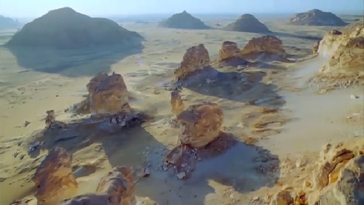
The Desert Plateau
Note:
Note:
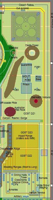
The desert plateau region is actually more like a vast staircase with two steps; it is a land area consisting of two main sections, each of which is its own distinct plateau. These two plateaus hold two of Inisfree's three deserts, and it is on these two plateaus that the majority of Inisfree's military training and housing is.
Dimensions & Layout:
Both plateaus are two miles wide. The higher of the two is five miles along its long axis, giving it 10 square miles of land. The lower of the two is three miles along its long axis, giving it six square miles of land. Together they form what is more conveniently and collectively referred to as 'the desert plateau', which, thereby, includes about 16 square miles of Inisfree's surface land.
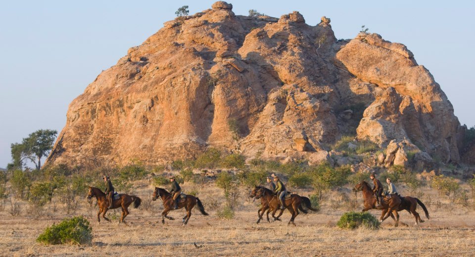
At one end of the higher section of this desert plateau, near one of the four corners of Inisfree, is the Military Aerospaceport. Moving toward the other end of this section of the desert plateau, one will encounter the Devil's Tower II (based on its namesake Wyoming landmark), then three F.O.B.s (Forward Operating Bases; military outposts used to train Inisfreean military personnel for deployments to places in which they will be staffing similar F.O.B.s), a fake abandoned prison (used for further training of those same personnel; in urban warfare, etc.), then a man-made (more accurately, an Inisfreean-made) volcano (also used for their training, as well as for some slave and prisoner punishments), and, lastly, Uluru II (Inisfree's version of its namesake Australian landmark). This higher plateau section is three quarters of a mile above Inisfree's ground-level, the brief mountain range upon it rises another quarter of a mile, as does its man-made volcano and Uluru II feature. The Devil's Tower II, half a mile up from this plane.
Separating that higher plateau from its lower neighboring one, there is a canyon which is a small branch off the main one. Then, the second of the two sections of this desert plateau begins. On it, adjacent this narrow canyon branch, there is the third and most advanced of the ODST ranges (where troops inserted from orbit practice landing in live-fire impact ranges, such as during artillery barrages), then the second of these ODST ranges, along with various small-arms and crew-served weapon systems firing ranges on its flank tucked up against the foot-hills of its own adjacent, brief mountain range, and, lastly, the fenced off military town of barracks, dining halls, classroom buildings, medical clinics, supply depots, central issuing facilities, armories, motor-pools, and guard shacks. This lower portion of the overall desert plateau is half a mile above Inisfree's ground-level, and its brief mountain range rises another quarter of a mile.
Special Features:
Practice wars, battles, and skirmishes are all regularly scheduled out here, and these often look like Star Wars laser battles at night due to how their signaling flares (sometimes called 'pop-ups' or 'lume'), tracers (phosphorous-tipped bullets), and other light-emitting devices look during that time. During Antarctica's dark season (when the Sun never rises for months in a row), this effect is especially pronounced and amazing. Spectators can enjoy front-row seats to these major combat rehearsal events if escorted by an Inisfreean elite (called a Master Female, as Inisfreeans do not like the sound of the word 'mistress'), and all other interested parties are allowed to watch from just behind the ridge-line of either of the two brief mountain ranges which act as noise deflection barriers on the edge of this military region and where its neighboring civilian regions begin.
Dimensions & Layout:
Both plateaus are two miles wide. The higher of the two is five miles along its long axis, giving it 10 square miles of land. The lower of the two is three miles along its long axis, giving it six square miles of land. Together they form what is more conveniently and collectively referred to as 'the desert plateau', which, thereby, includes about 16 square miles of Inisfree's surface land.
At one end of the higher section of this desert plateau, near one of the four corners of Inisfree, is the Military Aerospaceport. Moving toward the other end of this section of the desert plateau, one will encounter the Devil's Tower II (based on its namesake Wyoming landmark), then three F.O.B.s (Forward Operating Bases; military outposts used to train Inisfreean military personnel for deployments to places in which they will be staffing similar F.O.B.s), a fake abandoned prison (used for further training of those same personnel; in urban warfare, etc.), then a man-made (more accurately, an Inisfreean-made) volcano (also used for their training, as well as for some slave and prisoner punishments), and, lastly, Uluru II (Inisfree's version of its namesake Australian landmark). This higher plateau section is three quarters of a mile above Inisfree's ground-level, the brief mountain range upon it rises another quarter of a mile, as does its man-made volcano and Uluru II feature. The Devil's Tower II, half a mile up from this plane.
Separating that higher plateau from its lower neighboring one, there is a canyon which is a small branch off the main one. Then, the second of the two sections of this desert plateau begins. On it, adjacent this narrow canyon branch, there is the third and most advanced of the ODST ranges (where troops inserted from orbit practice landing in live-fire impact ranges, such as during artillery barrages), then the second of these ODST ranges, along with various small-arms and crew-served weapon systems firing ranges on its flank tucked up against the foot-hills of its own adjacent, brief mountain range, and, lastly, the fenced off military town of barracks, dining halls, classroom buildings, medical clinics, supply depots, central issuing facilities, armories, motor-pools, and guard shacks. This lower portion of the overall desert plateau is half a mile above Inisfree's ground-level, and its brief mountain range rises another quarter of a mile.
Special Features:
Practice wars, battles, and skirmishes are all regularly scheduled out here, and these often look like Star Wars laser battles at night due to how their signaling flares (sometimes called 'pop-ups' or 'lume'), tracers (phosphorous-tipped bullets), and other light-emitting devices look during that time. During Antarctica's dark season (when the Sun never rises for months in a row), this effect is especially pronounced and amazing. Spectators can enjoy front-row seats to these major combat rehearsal events if escorted by an Inisfreean elite (called a Master Female, as Inisfreeans do not like the sound of the word 'mistress'), and all other interested parties are allowed to watch from just behind the ridge-line of either of the two brief mountain ranges which act as noise deflection barriers on the edge of this military region and where its neighboring civilian regions begin.
沙漠


高原