Terrain Features News: Inisfree now includes extensive cave networks and faux lava flows.
Terrain Features
Terrain Features
Note:
Note:
Our city has at least one major section, which we call a region, devoted to each type of natural environment. Inspired by Disney World and states such as Utah, where residents and guests can enjoy nearly every type of terrain and climate within a short drive from their homes and businesses, we have built Inisfree to offer the same eclectic setting.
Dimensions & Layout:
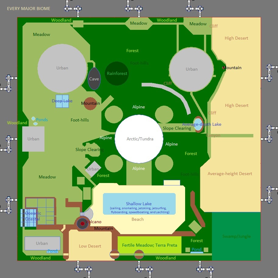
Inisfree is built around a central, stand-alone mountain which is capped with a circular plateau of snow, the melting of which is channeled into eight large waterfall spouts which then feed the tributaries and canals radially spreading down and out from this central mountain. There is a bowl-shaped crater-like depression on one quadrant of the snowy plateau, and a circular cliff separating the plateau from surrounding downward slope of the mountain. The core of this mountain is a giant hollow cylinder measuring 2 miles in horizontal diameter and standing one mile tall from its base on the horizon plane to where its top is roofed by a hollow dome with a radius of 1 mile. The main access routes for this hollow core are the 4 diagonal cylindrical shafts connecting it to the surface slope near the top of the mountain, each shaft oriented up and out toward one of the ordinal directions (a.k.a. intermediate or intercardinal, as opposed to cardinal directions).
The border that encloses Inisfree is, when viewed from above, a thick square wall measuring 10 miles along each of its inner sides. This wall may be thought of as a rock cliff on inside, and an ice cliff on the outside, with a rock plateau along its top, a wedge-like canyon dividing its top into an outer and inner section, those sections along with the wedge-like canyon making up the three thirds of its top. There are 12 routes through this wall, each of which may be thought of as a mountain pass, though only one of them is usually ever opened for public or outsider (a.k.a. Outlander) traffic.
With a clock superimposed over our city's map, the rolling foot-hills region, much like the Highlands of Scotland, are in the octant section expanding toward the 12 o'clock position along the city's outer wall. These foot-hills stop about two thirds of the way in from the city's border, meeting a sheer cliff in the form of a horizontal quarter of the circumference of a circle, and this is where their side of the central mountain begins its steeper ascent toward the snowy plateau atop it.
Our two desert plateaus take up the right side of the map, two miles across all the way down from the 1 o'clock position (basically the top right corner) all the way down to where the 2x2 mile swamp and marshes region is at the bottom right corner of the map. Each of these plateaus has one lazy-S shaped mountain range atop it; the higher plateau's mountain range being about two miles long, the lower plateau's about 2.75 miles long. The higher plateau also has a variant of the Devil's Tower landform from Wyoming, Inisfree's 2nd largest faux volcano, and a variant of the Uluru landform from Australia.
The desert plateaus are separated from each other by a narrow canyon, and from the foot-hills and part of the central mountain by a wider, longer, deeper canyon. The top end of this longer canyon is fed by one of the waterfalls of a tall spire of rock on its foot-hills side, and the opposite end of this longer canyon connects with a shallow, circular pond. It should also be noted that the tall spire of rock has three waterfalls, one of which is fed from a creek meeting its base, and the other connecting with the moat of the nearby dome-shaped temple.
About at the 6 o'clock position along the inner face of the city's wall is where the 1x3 mile rectangle of crops are. This is a flat meadow-like region with varying water tables and regulated humidities, and is bordered on one of its long sides and one of its short sides by a relatively low mountain range to help keep out any sand from the adjacent beach and low desert regions.
Continuing toward the bottom left corner of the map, two more regions are found; first the low desert which measures about 1x2 miles, then a flat meadow measuring 1x2 miles. The low desert is bordered on three sides by a low mountain range, the meadow on two sides. Moving instead up from the crops region, one will find a 1x3 lake bordered by a sandy beach ranging in width from shore out .25 to .75 of a mile. The bottom left corner of this beach is dominated by the city's largest faux volcano which shares another of its sides with the low desert.
Adjacent the top and outermost corner of the 1x2 meadow is a roughly .75x.75 deep lake-like area divided into giant aquarium sections. Beyond it, extending all the way up to the top left corner of the map, ranging in width from 2 to 3.25 miles, is the city's largest meadows region.
About two fifths of the way from the top left corner of the map to the circular cliff surrounding the snowy plateau of the central mountain is what would be a perfectly flat circle of terrain if it was not for the hundreds of skyscrapers, many standing half a mile tall or taller, which occupies this region. If a dense urban Coruscant-like environment can be considered a type of terrain, that is what you will find covering this region.
The last surface terrain feature and mini-region worth mentioning is what you will find in the middle of the left side of the map, exactly where the '9' of the 9 o'clock position would be; it is here that there is a perfectly square, 1x1 mile flatland paved in a material which looks like smooth asphalt and feels like the slightly cushiony surface of a basketball court. This is the largest parking lot, landing pad, and parade formations area in the city, which is also used for events reminiscent of big State Fairs with hundreds of yurt-style tents.
Below the surface is an inverted dome of territory called the Undercity. This is the lower hemisphere of Inisfree. It has a 10 mile horizontal diameter, extends down 5 miles from the horizon plane to its lowest point, and contains many giant man-made subterranean chambers. One of these subterranean chambers is a town-sized drive-through cave called the Uber Geode, and it connects to a slightly lower drive-through cave called the Underway, which is a horizontal tube about 500' wide and 6.75 miles from front to back. It has 26 ellipsoid annexes; branch caves, per side; 52 in total. This subterranean region is dwarfed, however, by each of the 16 diagonal hollow cylinder chambers, as each of these chambers has both a length and diameter of over 2 miles. There are also vertical hollow cylinders still deeper in this lower hemisphere of the city, these chambers ranging in height from 2.3 to 3.75 miles, each of them having a 1 mile horizontal diameter. And, near the internal vertices of this lower hemisphere, and in a cluster of four near its base, are hollow spheres measuring 1 mile in diameter; 8 in total.
Regions:
The following are links to the major and distinct environmental sections of our city:
Dimensions & Layout:
Inisfree is built around a central, stand-alone mountain which is capped with a circular plateau of snow, the melting of which is channeled into eight large waterfall spouts which then feed the tributaries and canals radially spreading down and out from this central mountain. There is a bowl-shaped crater-like depression on one quadrant of the snowy plateau, and a circular cliff separating the plateau from surrounding downward slope of the mountain. The core of this mountain is a giant hollow cylinder measuring 2 miles in horizontal diameter and standing one mile tall from its base on the horizon plane to where its top is roofed by a hollow dome with a radius of 1 mile. The main access routes for this hollow core are the 4 diagonal cylindrical shafts connecting it to the surface slope near the top of the mountain, each shaft oriented up and out toward one of the ordinal directions (a.k.a. intermediate or intercardinal, as opposed to cardinal directions).
The border that encloses Inisfree is, when viewed from above, a thick square wall measuring 10 miles along each of its inner sides. This wall may be thought of as a rock cliff on inside, and an ice cliff on the outside, with a rock plateau along its top, a wedge-like canyon dividing its top into an outer and inner section, those sections along with the wedge-like canyon making up the three thirds of its top. There are 12 routes through this wall, each of which may be thought of as a mountain pass, though only one of them is usually ever opened for public or outsider (a.k.a. Outlander) traffic.
With a clock superimposed over our city's map, the rolling foot-hills region, much like the Highlands of Scotland, are in the octant section expanding toward the 12 o'clock position along the city's outer wall. These foot-hills stop about two thirds of the way in from the city's border, meeting a sheer cliff in the form of a horizontal quarter of the circumference of a circle, and this is where their side of the central mountain begins its steeper ascent toward the snowy plateau atop it.
Our two desert plateaus take up the right side of the map, two miles across all the way down from the 1 o'clock position (basically the top right corner) all the way down to where the 2x2 mile swamp and marshes region is at the bottom right corner of the map. Each of these plateaus has one lazy-S shaped mountain range atop it; the higher plateau's mountain range being about two miles long, the lower plateau's about 2.75 miles long. The higher plateau also has a variant of the Devil's Tower landform from Wyoming, Inisfree's 2nd largest faux volcano, and a variant of the Uluru landform from Australia.
The desert plateaus are separated from each other by a narrow canyon, and from the foot-hills and part of the central mountain by a wider, longer, deeper canyon. The top end of this longer canyon is fed by one of the waterfalls of a tall spire of rock on its foot-hills side, and the opposite end of this longer canyon connects with a shallow, circular pond. It should also be noted that the tall spire of rock has three waterfalls, one of which is fed from a creek meeting its base, and the other connecting with the moat of the nearby dome-shaped temple.
About at the 6 o'clock position along the inner face of the city's wall is where the 1x3 mile rectangle of crops are. This is a flat meadow-like region with varying water tables and regulated humidities, and is bordered on one of its long sides and one of its short sides by a relatively low mountain range to help keep out any sand from the adjacent beach and low desert regions.
Continuing toward the bottom left corner of the map, two more regions are found; first the low desert which measures about 1x2 miles, then a flat meadow measuring 1x2 miles. The low desert is bordered on three sides by a low mountain range, the meadow on two sides. Moving instead up from the crops region, one will find a 1x3 lake bordered by a sandy beach ranging in width from shore out .25 to .75 of a mile. The bottom left corner of this beach is dominated by the city's largest faux volcano which shares another of its sides with the low desert.
Adjacent the top and outermost corner of the 1x2 meadow is a roughly .75x.75 deep lake-like area divided into giant aquarium sections. Beyond it, extending all the way up to the top left corner of the map, ranging in width from 2 to 3.25 miles, is the city's largest meadows region.
About two fifths of the way from the top left corner of the map to the circular cliff surrounding the snowy plateau of the central mountain is what would be a perfectly flat circle of terrain if it was not for the hundreds of skyscrapers, many standing half a mile tall or taller, which occupies this region. If a dense urban Coruscant-like environment can be considered a type of terrain, that is what you will find covering this region.
The last surface terrain feature and mini-region worth mentioning is what you will find in the middle of the left side of the map, exactly where the '9' of the 9 o'clock position would be; it is here that there is a perfectly square, 1x1 mile flatland paved in a material which looks like smooth asphalt and feels like the slightly cushiony surface of a basketball court. This is the largest parking lot, landing pad, and parade formations area in the city, which is also used for events reminiscent of big State Fairs with hundreds of yurt-style tents.
Below the surface is an inverted dome of territory called the Undercity. This is the lower hemisphere of Inisfree. It has a 10 mile horizontal diameter, extends down 5 miles from the horizon plane to its lowest point, and contains many giant man-made subterranean chambers. One of these subterranean chambers is a town-sized drive-through cave called the Uber Geode, and it connects to a slightly lower drive-through cave called the Underway, which is a horizontal tube about 500' wide and 6.75 miles from front to back. It has 26 ellipsoid annexes; branch caves, per side; 52 in total. This subterranean region is dwarfed, however, by each of the 16 diagonal hollow cylinder chambers, as each of these chambers has both a length and diameter of over 2 miles. There are also vertical hollow cylinders still deeper in this lower hemisphere of the city, these chambers ranging in height from 2.3 to 3.75 miles, each of them having a 1 mile horizontal diameter. And, near the internal vertices of this lower hemisphere, and in a cluster of four near its base, are hollow spheres measuring 1 mile in diameter; 8 in total.
Regions:
The following are links to the major and distinct environmental sections of our city:
- [Bioluminescent Greenbelt]
- [Canyon(s)]
- [Cave / Geode Mouth]
- [Desert] ('rainbow dunes')
- [Greenbelts]
- [Plateau(s)]
- [Prairie] (inside border of the Perimeter Wall)
- [Swamp]
- [Tundra] (Snow Dunes Area whose perimeter just above The Avalanche Ring Wall)
_
Note
TBA
TBA
地形
特徵


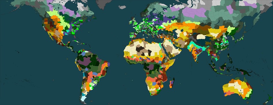
Biomes Checklist
We have at least 1 of each biome and climate in Inisfree so:
We have at least 1 of each biome and climate in Inisfree so:
- we can always train in each
- we know how to maintain each
- we know which little changes cause which different things in each
- we know how to control their borders with different biomes (different combinations of borders, too)
- we know how to terraform each
- we know how to grow food in each
- we know how to collect (or create) potable water in each
- we have a basic back-up copy and template for each
- we can test which flora and fauna can be introduced stably into each
- we can test which new flora and fauna can grow and stabilize in each
- all our guests will have multiple ideal environments they desire or are already comfortable with
- even when the city itself is in transit, all guests will continuously have the option to experience any and all biomes